Learn the map
How to read a map legend
A legend explains what a map’s symbols mean. Match the shape, line style and label before deciding what a feature represents.
On this page
Match a feature to its legend symbol
Pick one feature on the map and look for the same symbol in the legend. Check its shape, color and line style together. A blue line means a river on this practice map, but another map may use blue differently. Always use the legend for the map in front of you.
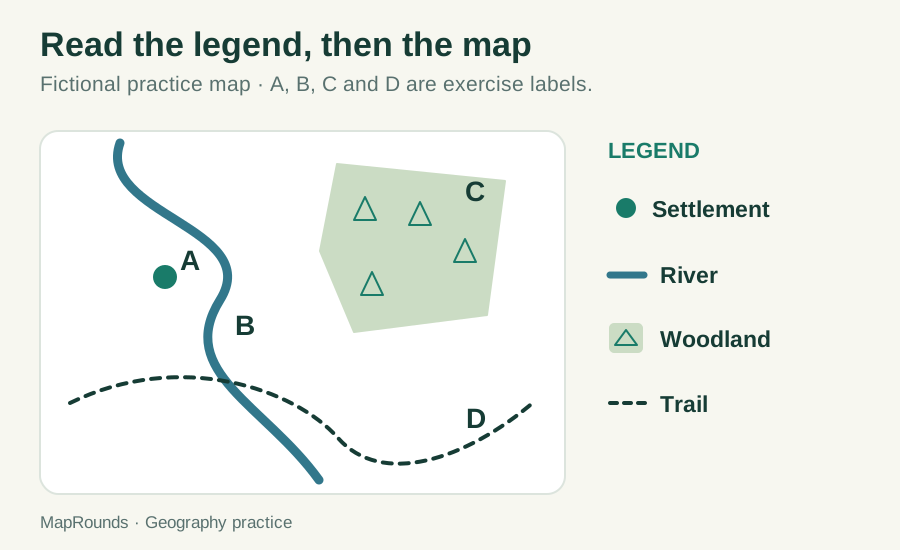
| Representation | Meaning in this practice map | What it does not tell you alone |
|---|---|---|
| Point: filled circle | Settlement | The settlement’s exact area or population |
| Line: blue and solid | River | The river’s actual width |
| Area: green with tree marks | Woodland | The number of individual trees |
| Line: dark and dashed | Trail | A political boundary |
Separate symbols from real-world size
A settlement may need a large dot to be easy to see. A river may be drawn wider than it really is. Those choices make the map readable; they do not give you the settlement’s boundaries or the river’s true width. Use an appropriate scale and data source when you need to measure distance or area.
A map may use a representative point when an outline would be too small or too detailed. The point helps you locate the feature without showing its full size. MapRounds explains these markers in the map notes.
Try it
- 1. Feature A is a filled circle. What kind of feature does it identify?
- 2. Feature B follows the blue solid line. Is it a river or a trail?
- 3. Feature C lies in the green patterned area. What does the area represent?
- 4. Feature D follows a dashed dark line. Does this legend label it as a national border?
- 5. Can you calculate a settlement’s population from the diameter of its circle in this figure?
Check your answers
- 1. A settlement.
- 2. A river.
- 3. Woodland.
- 4. No. The dashed line means trail in this map.
- 5. No. This legend does not encode population by circle size.
Read the other map notes too
The legend explains symbols. The title and scope notes explain which places the map covers. A north arrow gives direction, and a scale helps with distance where appropriate. Read them together: a symbol can be clear even when the place it marks is outside the current quiz.
Try a related quiz
Sources and further reading
Original MapRounds editorial text and diagrams: CC BY 4.0. Third-party source text and flag artwork retain their own terms; see the source and asset records.